

» Destination's informations
Back to map �North Carolina
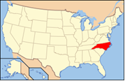
 North Carolina is a state located on the Atlantic Seaboard in the Southern United States. The state borders South Carolina and Georgia to the south, Tennessee to the west and Virginia to the north. North Carolina contains 100 counties. Its capital is Raleigh, and its largest city is Charlotte. In the past five decades, North Carolina's economy has undergone a transition from reliance upon tobacco and furniture to a more diversified economy with an emphasis on engineering, biotechnology, and finance.
 North Carolina has a wide range of elevations, from sea level on the coast to 6,684 feet (2,037 m) at Mt. Mitchell, the highest point in the Eastern US.
 Also known as : Tar Heel State
Capital : Raleigh
Largest city : Charlotte
Population : 9 222 914
Abbreviation : NC
Main cities : Charlotte, Raleigh, Winston-Salem, Greensboro, Durham, Fayetteville, Asheville, Wilmington

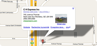
 743, Avenue Thomas